 LandmAIn
The LandmAIn briefing
Find the land where infrastructure and opportunity align.
LandmAIn brings land, infrastructure, and public records into one clear view. Our eastern Denver metro demonstration shows how a consistent screening process helps development teams compare sites and focus their next move.
A connected view of the eastern Denver metro.
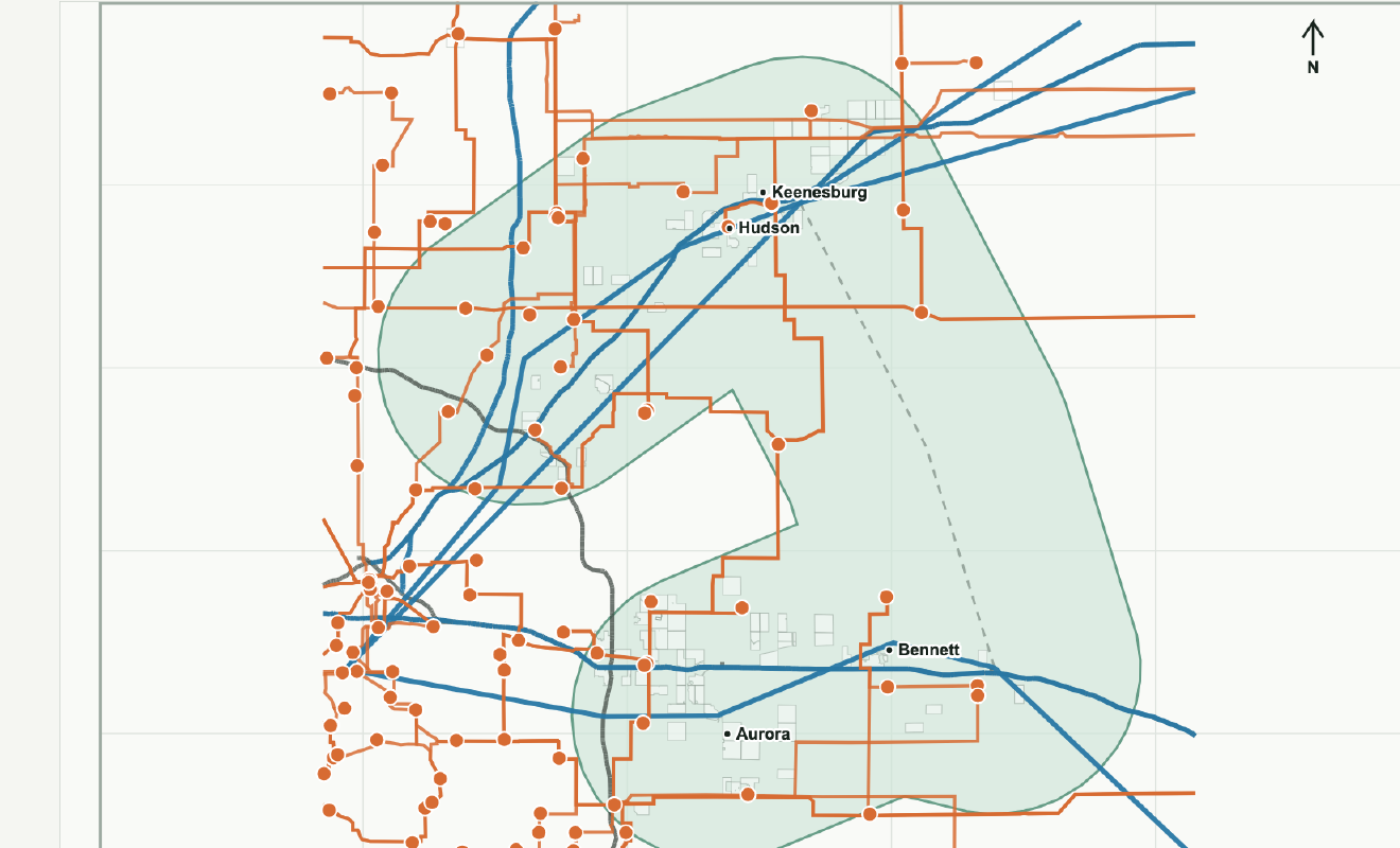
The current study follows the corridor from Watkins and Bennett north through Hudson and Keenesburg. LandmAIn brings transmission, substations, fiber corridor evidence, highways, water context, and land characteristics together on a shared map.
That view gives each site a place in the wider development picture. Teams can compare infrastructure relationships across the corridor, then explore the parcel and policy details that shape an individual opportunity.
One process, from corridor to project.
LandmAIn organizes site research into three connected stages. Each stage adds the detail a development team needs for a more focused conversation.
Map the opportunity.
Compare parcel scale and infrastructure relationships. Bring power, fiber, highways, and water context into the same screen so each opportunity can be evaluated on a consistent basis.
Understand the development path.
Connect the map to zoning, jurisdiction, land-use processes, and community context. Organize the policy details that shape how a project can move forward.
Focus the next conversation.
Build a clear sequence for utility coordination, carrier discussions, water and wastewater planning, title review, and site control. Give each conversation a defined purpose and a useful evidence package.
Five profiles show the process at work.
The public demonstration presents five representative screens from the larger research set. Each profile uses the same structure: a local map, infrastructure context, policy findings, and the next development question. The shared format makes differences between locations easier to assess.
Aurora East A
Connects a broad land screen with public transaction research, infrastructure context, and parcel-level review.
Aurora East B
Provides a comparison case for evaluating highway and fiber relationships alongside the power pathway.
Keenesburg North A
Brings power, fiber, and water relationships together with jurisdiction and land-use research.
Keenesburg South A
Connects the physical infrastructure screen with the industrial rezoning process.
Weld Industrial Context
Examines industrial zoning, power context, and site-control research within the same decision framework.
Compare the five screens or open the opportunity profiles for standardized map sheets.
Put land-use research to work early.
LandmAIn connects each location to its governing jurisdiction and development process. The Weld County review adds a policy layer to the corridor ranking, helping teams organize zoning, municipal boundaries, and industrial land-use pathways alongside the infrastructure evidence.
This creates a practical order for the work. Start with jurisdiction and land use. Build the utility discussion around the project's power needs. Bring fiber, water, access, and site-control research into a coordinated plan.
A useful package for the next decision.
The maps, profiles, and research give investors, landowners, and development teams a shared basis for discussion. Source dates and a consistent review format keep the reasoning easy to follow as the work progresses.
- Corridor maps put infrastructure relationships in geographic context.
- Comparable site profiles bring land, policy, and development questions into one format.
- A focused research sequence helps teams direct time and attention to the next decision.
LandmAIn turns a broad land search into a structured development conversation. The result is a clearer view of where to focus, what to discuss, and how to advance the work.
Start with the site question in front of you.
Tell us about the location, project, or development decision you are working through.
Talk with LandmAIn